MEMBERSHIP
AMPLIFY
EN ESPAÑOL
Connect With Us
- Popular search terms
- Automobile
- Home + Renters
- Claims
- Fraud
- Hurricane
- Popular Topics
- Automobile
- Home + Renters
- The Basics
- Disaster + Preparation
- Life Insurance
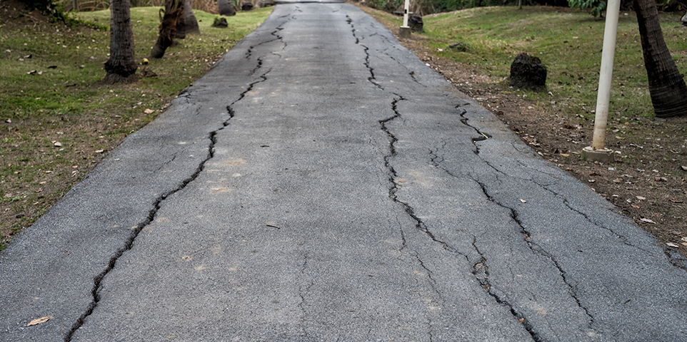
An earthquake is a sudden and rapid shaking of the earth caused by the breaking and shifting of rock beneath the earth’s surface. This shaking can sometimes trigger landslides, avalanches, flash floods, fires and tsunamis.
Millions of people across 42 states are at risk for damage from an earthquake, yet few purchase earthquake insurance to protect their property.
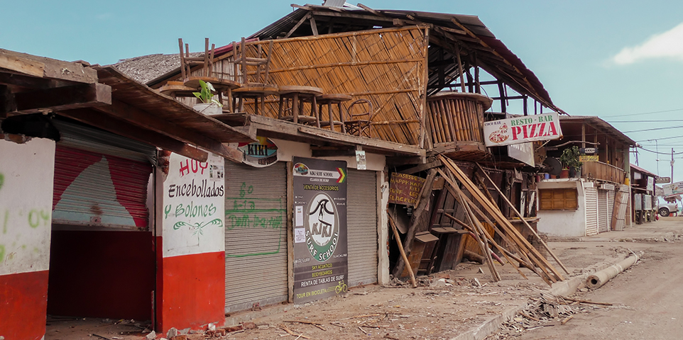
The potential cost of earthquakes has been growing because of increasing urban development in seismically active areas and the vulnerability of older buildings, which may not have been built or upgraded to current building codes.
Earthquakes in the United States are not covered under standard homeowners or business insurance policies. Coverage is available either in the form of an endorsement or as a separate policy for homeowners, renters and small business owners.
Unlike flood insurance, earthquake coverage is available from private insurance companies rather than from the government. Coverage for other kinds of damage that may result from earthquakes, such as fire and water damage due to burst gas and water pipes, is provided by standard home and business insurance policies in most states. Cars and other vehicles are covered for earthquake damage by comprehensive insurance which also provides protection against flood and hurricane damage as well as theft.
Insurers that don’t sell earthquake insurance may still be impacted by these catastrophes due to losses from fire following a quake. These losses could involve claims for business interruption and additional living expenses as well. Cars and other vehicles are covered for earthquake damage under the comprehensive part of the auto insurance policy.
Twenty-three percent of homeowners who had homeowners insurance responding to the 2020 Triple-I Consumer Poll said they had earthquake insurance, up from 15 percent in 2018. Homeowners in the West were most likely to have earthquake insurance, with 28 percent saying they had the coverage, followed by the South at 25 percent; the Northeast at 21 percent; and the Midwest at 16 percent. See the Poll report for details.
Deductibles and Costs: Earthquake insurance carries a deductible, generally in the form of a percentage rather than a dollar amount. Deductibles can range anywhere from 2 percent to 20 percent of the replacement value of the structure. This means that if it cost $100,000 to rebuild a home and there was 2 percent deductible, the consumer would be responsible for the first $2,000 dollars. Insurers in states like Washington, Nevada and Utah, with higher than average risk of earthquakes, often set minimum deductibles at around 10 percent. In most cases, consumers can get higher deductibles to save money on earthquake premiums.
Premiums also differ widely by location, insurer and the type of structure that is covered. Generally, older buildings cost more to insure than new ones. Wood frame structures generally benefit from lower rates than brick buildings because they tend to withstand quake stresses better. Regions are graded on a scale of 1 to 5 for likelihood of quakes, and this may be reflected in insurance rates offered in those areas. The cost of earthquake insurance is calculated on “per $1,000 basis.” For instance, a frame house in the Pacific Northwest might cost between one to three dollars per $1,000 worth of coverage, while it may cost less than fifty cents per $1,000 on the East coast.
A brick home would cost approximately $3 to $15 dollars per $1,000 in the Pacific Northwest, while it would cost between 60 to 90 cents in New York. Earthquake insurance is available from most insurance companies in most states. California law requires homeowners insurance companies to offer earthquake coverage to their homeowners insurance policyholders. Homeowners can decide to purchase it, purchase a policy from another insurer or decline it altogether.
In January 1994 when the Northridge earthquake, a magnitude 6.7 quake, struck Southern California, causing an estimated $34.0 billion (in 2025 dollars) in insured losses, the insurance industry ended up paying out more in claims for this quake than it had collected in earthquake premiums over the preceding 30 years. While no insurer became insolvent, some came very close.
To recover their financial strength and to be better prepared for the next earthquake, most insurers began to limit their exposure to earthquakes by writing fewer new homeowners insurance policies. In addition, most insurers filed for both rate increases and increases in deductibles from the 10 percent that was current then to 15 percent or higher. This triggered a crisis that by mid-1996 threatened the vitality of the state’s housing market and stalled the state’s recovery from recession.
In 1996 the California Legislature established the California Earthquake Authority (CEA) as a publicly managed, largely privately funded entity operating only in California. The CEA is the largest provider of residential earthquake insurance in the U.S., with 1,113,964 policies in force at the end of February 2020. The CEA provides two-thirds of the residential earthquake insurance policies sold in California and has an annual premium revenue of more than $630 million dollars. The program is actuarially sound (found to have sufficient funds by financial experts) with over $18 billion available to pay claims from devastating earthquakes.
CEA coverage
All of the CEA’s residential policies have deductibles of 5 percent to 25 percent in 5 percent increments, depending on the homeowners’ choice. The deductibles are calculated as a percentage of the coverage cost of the home (dwelling). In general, premiums vary across the state and across individual policies, due to the policyholder’s risk of earthquake damage and other factors including location, the age and construction type of the house, and the coverage amounts and deductibles selected.
Homeowners: The program offers two homeowners policies: standard and choice. The standard policy covers earthquake damage to the home and structures attached to it, such as a garage. Other structures, such as detached garages, and pools are not covered. Personal property is covered up to a $200,000 limit; additional living expenses are included up to a $100,000 limit; and building code upgrades and emergency repairs are covered. The homeowners choice policy includes the standard coverage, plus coverage for special “breakable” possessions, such as china and glassware, and exterior masonry veneer.
Mobile and manufactured homes: Same as homeowners, but does not offer exterior masonry veneer coverage.
Condominiums: The CEA offers a number of optional coverages. Deductibles are calculated as a percentage of the coverage cost of the building property. That option covers damage to parts of the inside of a condo unit, such as windows, with a limit of $100,000; and personal property which includes loss of use, with a limit of $200,000. Other options are coverage for loss assessments from homeowners associations, building code upgrades, emergency repairs and breakables.
Renters: Deductibles are calculated as a percentage of the coverage limits for personal property, which is covered up to $200,000. Other coverages available are for loss of use up to a limit of $100,000, emergency repairs and coverage for breakables.
For hundreds of millions of years, the forces of plate tectonics have shaped the earth as the huge plates that form the Earth's surface move slowly over, under, and past each other.
Sometimes the movement is gradual. At other times, the plates are locked together, unable to move. When the pressure building up grows strong enough, the plates break free causing the ground to shake and rupture along fault lines, or zones of weakness.
One of the most famous faults is the San Andreas Fault, which extends about 600 miles from the Gulf of California northwest along the California coast. The 1906 San Francisco earthquake was caused by movement of the San Andreas Fault.
Quakes can produce different kinds of shaking. Some, like the 6.8 magnitude (see section on Earthquake Measurement) Northridge quake, are thrust fault quakes, which cause violent up-and-down, rather than the more common side-to-side movement. Ground shaking from earthquakes can collapse buildings and bridges as well as trigger landslides, avalanches, floods, fires, and tsunamis. Buildings with foundations resting on unconsolidated landfill and other unstable soil, and trailers and homes not tied to their foundations are at risk because they can be shaken off their mountings during an earthquake.
According to the U.S. Geological Survey, several million earthquakes occur worldwide each year. While the vast majority are undetectable, about 50 earthquakes each day are located, or 20,000 a year. In any given year, about 16 of these earthquakes are expected to be major, including 15 in the magnitude 7 range and one magnitude 8.0 or greater earthquake.
About 81 percent of the world’s largest earthquakes occur in the Circum-Pacific seismic belt. The area extends from Chile, northward along the western South American coast through Central America, Mexico, the west coast of the United States and the southern part of Alaska, through the Aleutian Islands to Japan, the Philippine Islands, New Guinea, the island groups of the Southwest Pacific and to New Zealand.
The most powerful earthquake on record occurred in Chile on May 22, 1960. The magnitude 9.5 quake caused $550 million in damage, killed more than 2,000 people and injured more than 3,000. It also caused a tsunami, which caused additional destruction in Hawaii, Japan, the Philippines and the West coast of the United States.
A 2024 U.S. Geological Survey report found that nearly 75 percent of the United States is vulnerable to damaging earthquakes and intense ground shaking, with 37 states experiencing quakes exceeding magnitude 5 during the last 200 years.
The 16 states at highest risk are Alaska, Arkansas, California, Hawaii, Idaho, Illinois, Kentucky, Missouri, Montana, Nevada, Oregon, South Carolina, Tennessee, Utah, Washington, and Wyoming.
The Atlantic coastal corridor is also at increased risk, impacting dense population centers such as Boston, New York, Philadelphia, and Washington, D.C. Though the seismic hazard remains low compared to high-risk states, the elevated likelihood of quakes in these urban areas places millions of people at greater risk.
Nearly 49 million people across the country are “somewhat likely” to experience an earthquake in the next 50 years, at a 50 percent probability. Roughly 118 million people have a 10 percent chance to experience a quake, and 140 million have a less than 10 percent chance.
In the continental United States, earthquakes occur most frequently west of the Rocky Mountains. Historically, many of the most violent earthquakes have occurred in the central United States. The largest earthquake in the continental U.S. occurred along the New Madrid fault in Missouri, where a three-month long series of quakes in 1811–1812 included three quakes larger than a magnitude of 8.
The state with the largest earthquakes overall is Alaska, which has recorded multiple magnitude 8 or greater quakes. The state with the costliest and most damaging earthquakes is California.
Earthquake risk in the Western United States: Although the entire Northwest of the United States is at high risk of earthquakes, eight of the 10 costliest earthquakes in the last century occurred in California. According to the U.S. Geological Survey, there is a 72 percent probability that an earthquake of magnitude 6.7 will strike the San Francisco Bay area over the next 30 years.
Earthquake risk in the Central United States: The New Madrid Fault zone lies within the central Mississippi valley extending from northeastern Arkansas through southeastern Missouri, western Tennessee, Kentucky and southern Illinois. The last major earthquake, magnitude 8, occurred there in 1812. But scientists warn that this was not a freak occurrence. Earthquakes in central and eastern United States affect much larger areas than earthquakes of similar magnitude in the West. For example, the San Francisco earthquake of 1906 was felt 350 miles away, whereas the New Madrid earthquake of December 1811 rang church bells in Boston, Massachusetts, 1,000 miles away.
Earthquake risk in the Eastern United States: While the risk of an earthquake in the Northeast is not nearly as high as in the West, the region is seismically active. The largest earthquake in the East was a 7.5 temblor that struck Charleston, South Carolina, in 1886, killing over 60 people. A 6.0 earthquake struck Boston in 1755 and a 5.8 earthquake struck the northern part of New York State in 1944. Near New York City, there have been two 5.0 to 5.3 earthquakes, one in 1737 and the other in 1884.
Applied Insurance Research, a catastrophe modeling firm, points out that large numbers of buildings in both Boston and New York City were built long before the introduction of seismic building codes. Many of the older structures in the two cities are made of unreinforced masonry, the most vulnerable to earthquake damage. Worse, much of Boston is built on artificial fill, which can amplify seismic waves by as much as a factor of three. New York is less vulnerable, being largely built on bedrock.
The largest earthquake in the United States was a magnitude 9.2 quake that struck Alaska on March 28, 1964. The earthquake and ensuing tsunami caused more than $500 million in property losses, according to the National Geophysical Data Center.
The costliest earthquake in the U.S. was the Northridge, California, earthquake of January 17, 1994, with insured losses estimated at $15.3 billion, according to Aon ($34.0 in 2025 dollars).
The San Francisco Earthquake of 1906, would have caused insured losses of up to $105 billion, were the quake to hit under current economic and demographic conditions.
According to FEMA’s Hazus-based earthquake loss estimates, earthquakes continue to pose a significant and growing economic risk in the United States. These estimates reflect updated building inventories, population data and seismic hazard models, providing a more current understanding of potential losses.
The estimates primarily account for capital losses, including the cost to repair or replace buildings, contents and inventory, as well as loss of income from business interruption, rental income and wage losses. They generally do not include damage to critical facilities, transportation systems or utility infrastructure, nor do they capture broader indirect economic impacts.
Earthquake risk continues to increase due to several factors, including expanding urban development in seismically active regions, the vulnerability of older buildings that may not meet current building codes and the growing interdependence of modern economic systems.
While the largest potential losses are concentrated along the West Coast, earthquake risk is distributed more broadly across the country, reinforcing that earthquakes are a national concern. There are relatively high earthquake loss ratios throughout the western and central United States and in the Charleston area.
The study also highlights the importance of recognizing metropolitan areas with “low seismic hazard” but “high seismic risk,” such as New York City and Boston. These areas have dense concentrations of buildings and infrastructure that were often not designed with modern seismic standards. Although the likelihood of a major earthquake is lower, the potential economic impact is substantial. In addition, the perception of low risk can result in limited preparedness efforts among both the public and private sectors, increasing vulnerability to earthquake damage and disruption.
The size and magnitude of an earthquake is measured in several different ways. The Richter Scale measures the size of earthquake waves. It was developed by Charles Richter in the 1930s and is a logarithmic measurement of the amount of energy released by an earthquake, see below. The Mercalli Intensity Scale evaluates the intensity of a quake according to observed severity at specific locations. It rates the intensity on a Roman numeral scale that ranges from I to XII. Today, seismologists are using the Moment Magnitude Scale, which measures the size of the earthquake’s fault, and how much of the earth slips at the time of the quake. A number of readings are taken, averaged and then adjusted to generate numbers similar to the Richter Scale. This allows the magnitude of earthquakes measured on these new scales to be compared with earthquakes recorded earlier. According to the Moment Magnitude Scale, the severity of an earthquake is categorized as the following:
| 5.0 | Small |
| 5.0 – 6.0 | Moderate |
| 6.0 – 7.0 | Large |
| 7.0 - 7.8 | Major |
| 7.8 | Great |
An increase of one unit of magnitude, for example, from a 4.0 to a 5.0 quake, is a 10-fold increase in wave amplitude on a seismogram, or about a 30-fold increase in energy released. Thus, the difference between a 4.0 and a 6.0 magnitude quake would be a release of energy 900 times (30 times 30) as great as a 4.0 magnitude quake since the magnitude is a logarithmic value.
Although earthquakes cannot be prevented, science and engineering provide tools that can be used to reduce their damage. Science can now identify, with considerable accuracy, where earthquakes are likely to occur and what forces they will generate. Engineering can help provide design and construction techniques so that buildings and other structures can survive the tremendous forces of earthquakes.
To produce estimates of earthquake loss by geographic area, FEMA uses an earthquake loss estimation methodology called Hazards U.S. (HAZUS), developed in cooperation with the National Institute of Building Sciences. The loss estimation methodology is a software program that uses mathematical formulas and information about building stock, local geology and the location and size of potential earthquakes, economic data, and other information to estimate losses from a potential earthquake. HAZUS is capable of using two separate geographic information systems (MapInfo® and ArcView®) to map and display ground shaking, the pattern of building damage, and demographic information about a community. Once the location and size of a hypothetical earthquake is identified, HAZUS will estimate the violence of ground shaking, the number of buildings damaged, the number of casualties, the amount of damage to transportation systems, disruption to the electrical and water utilities, the number of people displaced from their homes, and the estimated cost of repairing projected damage and other effects.
In 1977 the United States Congress enacted the Earthquake Hazards Reduction Act, in recognition of the fact that earthquakes pose the greatest potential threat of any single-event natural hazard confronting the nation. The Act directed the President to "establish and maintain an effective earthquake hazards reduction program."
Congress then created the National Earthquake Hazards Reduction Program, which gave lead responsibility to the federal government to provide direction, coordination, research and other support to efforts aimed at earthquake hazard mitigation and preparedness. The Federal Emergency Management Agency (FEMA), the United States Geological Survey, the National Science Foundation, and the National Institute of Standards and Technology were assigned specific roles. Recommendations were included on the duties of state governments, local governments, private organizations and individuals.
Hydraulic fracturing, commonly known as fracking, is a drilling technique used to extract natural gas and oil from the ground. The process involves the disposal of wastewater by injecting it deep into the earth. There is evidence that the wastewater disposal process has contributed to an increase in the number of earthquakes.
The spate of earthquakes in Oklahoma over the last few years, including the 5.8 magnitude Pawnee quake in 2016, has been linked to the disposal of wastewater from oil production.
In January 2012 the U.S. Nuclear Regulatory Commission (NRC), the U.S. Department of Energy and the Electric Power Research Institute released a seismic study and model intended to help nuclear power plants in the central and eastern parts of the U.S. reassess their vulnerability to earthquakes. The study found that nuclear reactors in the region face bigger threats from big earthquakes than were previously recognized. The model, which came out of the study, replaces previous models used by the government and the nuclear power industry since the late 1980s. The NRC will require nuclear plant operators to conduct new studies for all 96 reactors in the regions.
($ millions)
|
||||||||||||||||||||||||||||||||||||||||||||||||||||||||||||||||||||||||
(1) Includes losses sustained by private insurers and government-sponsored programs such as the National Flood Insurance Program. Subject to change as loss estimates are further developed. As of January 2026.
(2) Adjusted for inflation by Aon using the U.S. Consumer Price Index.
Source: Aon.
|
(1) As of January 2020.
Source: ©2018 Munich Re, NatCatSERVICE.
United States Geological Survey, Earthquake Facts & Earthquake Fantasy
Insurance Institute for Business and Home Safety, Earthquake Resources
© Insurance Information Institute, Inc. - ALL RIGHTS RESERVED